Flooding:
Will It Be Your Turn Next?
THE
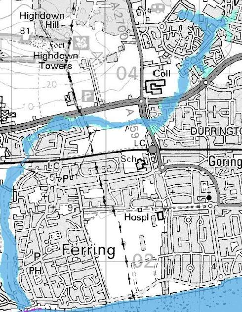
Map below, taken from the Environment Agency's website, shows the area at most risk (in blue) and possible risk (light green)
in times of prolonged rainfall and is the approximate area that saw the serious floods 30 or so years ago when dozens
of homes were flooded.
 Water
flows into the Ferring Rife from several sources one of those is the Lake - top
center
by caravan symbol. That Lake in turn is filled by aquifer fed streams and ditches that run
through the Titnore Woods complex. However the farmland
- Durrington's greenbelt - to the East of the Woods and North of the Tesco Extra at
present acts like a sponge, thus preventing a sudden rush of water into those streams
etc overwhelming the lake and subsequently the Ferring Rife.
Water
flows into the Ferring Rife from several sources one of those is the Lake - top
center
by caravan symbol. That Lake in turn is filled by aquifer fed streams and ditches that run
through the Titnore Woods complex. However the farmland
- Durrington's greenbelt - to the East of the Woods and North of the Tesco Extra at
present acts like a sponge, thus preventing a sudden rush of water into those streams
etc overwhelming the lake and subsequently the Ferring Rife.
In planning the development, that is now being
built on the farmland, some thought was given to the flooding risk heightened
by the run off from roofs and roads and a series of 'ponds' are to be created. That arrangement may be all well and good for a 'normal' rain fall, but
the climate is changing and as we saw recently the Ferring Rife was only just able to cope even with
the benefit of 125 acres of Greenfield's acting like a sponge.
If you live in the following roads a visit to the
Environment Agency's flood risk website (see
and enter your post code in the box on the r/h side bar) is advised so is an objection to the West Durrington
Development lodged with Worthing councils planning department (see)
ROADS etc at risk. Not in any particular order:
Varey road, Moore Cl, Bourne Cl, Calion Cl,
Squadron Dr, Essenhigh Dr, Thompson Cl, Ashburnham Cl, Deerswood Cl, Birches Cl,
Faraday Cl, Shelby Rd, Montreal Wy, Columbia Dr, Willow Cres, Romany Rd,
Sycamore Cl, Poplar Rd, Whitebeam Rd, Silver Birch Dr, Magnolia Cl, Holly Cl,
Chestnut Wk, Lilac Cl, Laurel Cl, Yeoman Rd, Yeoman Wy, Boxgrove, Harting Cl, Chailey Cl,
Patching Cl, Fittleworth Cl, Coleridge Cres, Ferring La, Ancren Cl, Downview
Ave, Downview Rd, Highdown Cl, Highdown Way, Rifeside Gdns, Brookside Cl, Langbury Lane, Onslow Caravan Pk. There is also
a risk to property's bordering the Rife in south Ferring.
With at least 5 floods of biblical proportions
in the UK since 2000 scientists are critical of the way we measure the risk of flooding.
Sir
David King,
the Government's former Chief Scientific Adviser speaking on the BBC’s
flagship News 24 programme (Saturday, 20 November 2009) following the
Cockermounth flood disaster, said that the 1 in 100 year event when measuring
the likelihood of flooding taking place was now obsolete. Climate change has
thrown doubt on the way we measure flood risk. If we built flood defenses to
cope with a 1 in 1000-year event, even that might prove inadequate.
Retiring in 2007 Sir
David had advised the government on everything from GM foods to stem cell
research, and foot-and-mouth disease to nuclear power for seven years. He was
also well
known for advocating a stop to building on flood plains.
All residents living in the above roads that
the sustainable urban drainage scheme (SUDS), referred to in the developers
application for the West Durrington Development, has been designed only to cope
with a 1in 100 year flood risk + 30% - and even then unproven. Are you reassured by
this SUDS scheme?
Back